NAVTEX in the United States
The International Maritime Organization has designated NAVTEX as the primary means for
transmitting coastal urgent marine safety information to ships worldwide. In the United States, NAVTEX is broadcast from Coast Guard facilities in Cape Cod, Chesapeake VA, Savannah GA, Miami FL, New Orleans LA, San Juan PR, Cambria CA, Pt. Reyes CA, Astoria OR, Kodiak AK, Honolulu HI, and Guam. Although NAVTEX broadcasts from Guam have not been operational since July 2018, Guam continues to broadcast NAVTEX on its backup frequency 4209.5 kHz. The Coast Guard first began operating NAVTEX from Boston in 1983.
NAVTEX coverage is reasonably continuous in the east, west and Gulf coasts of the United
States, as well the area around Kodiak Alaska, Guam and Puerto Rico. The U.S. has no coverage in the Great Lakes. Since the U.S. Coast Guard originally only installed NAVTEX at sites where Morse telegraphy transmissions were made previously, propagation analyses show some coverage gaps, particularly in the southeast United States and Alaska. NAVTEX broadcasts from Adak were permanently terminated in December 1996 due to the closure of the Naval facility there.
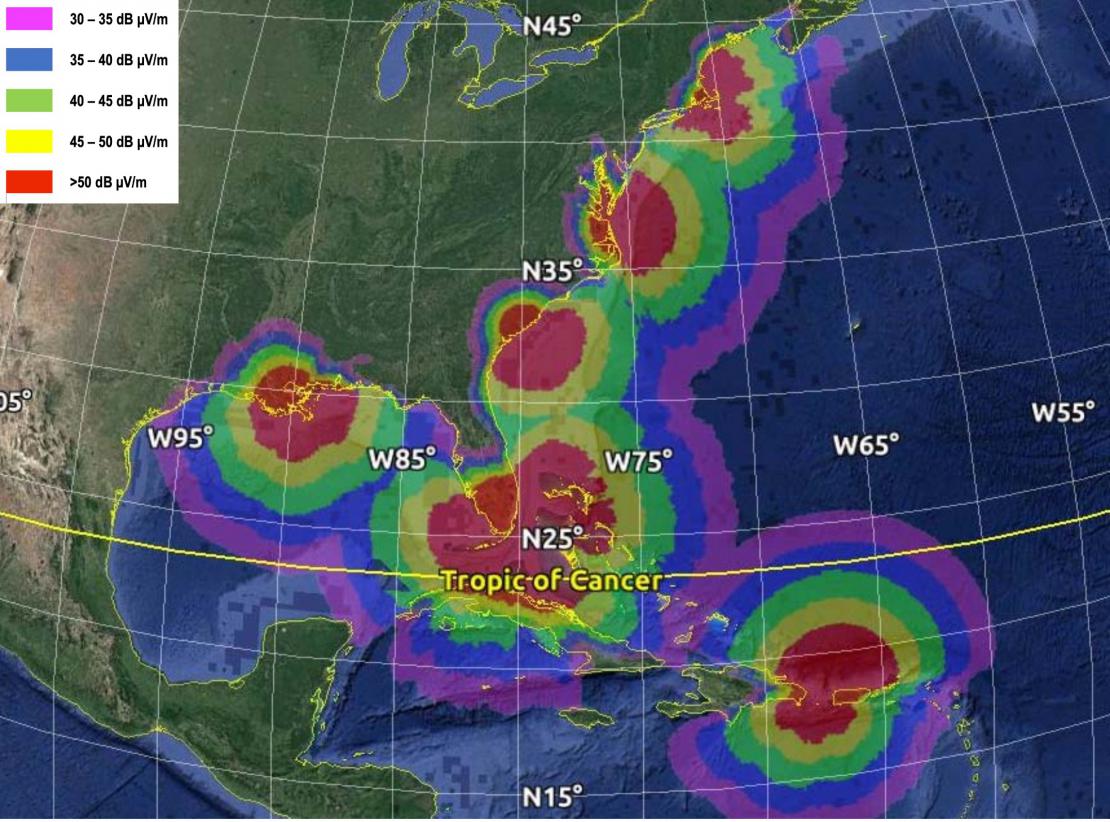
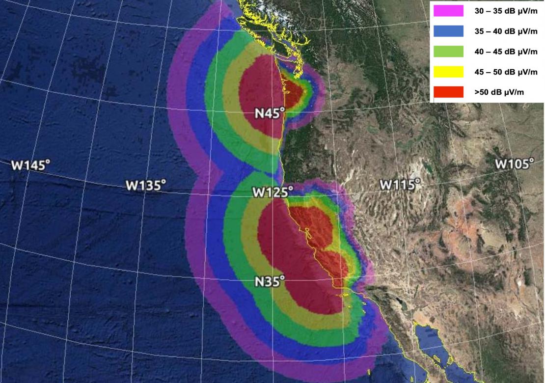
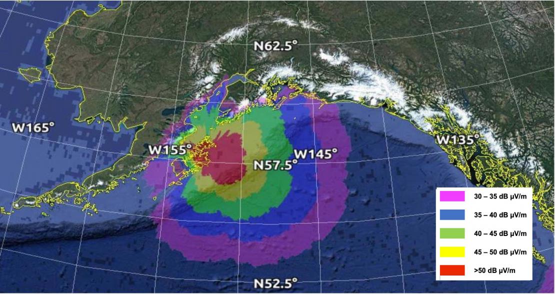
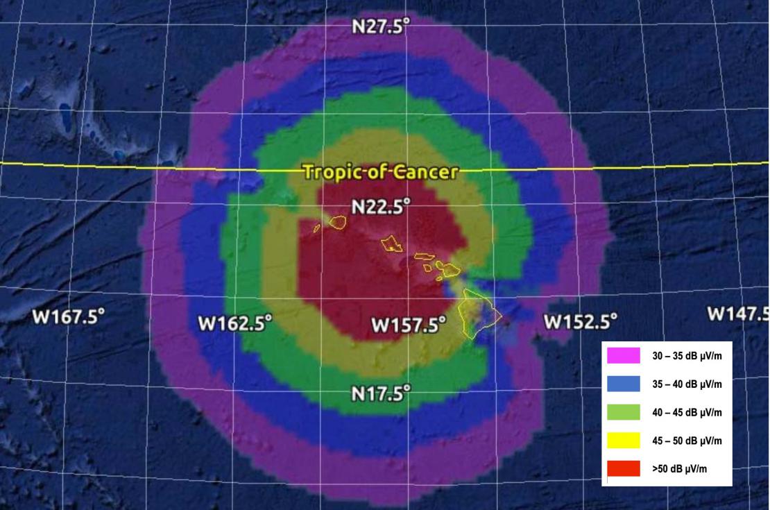
NAVTEX Predicted Coverage in the U.S.
- Eastern U.S NAVTEX Coverage
- Western U.S. NAVTEX Coverage
- Alaska NAVTEX Coverage
- Hawaii NAVTEX Coverage
These 2017 charts are based upon USCG Report No. CG-D-04-18 Navigational Telex (NAVTEX) Modeling, April 2017. Since coverage depends upon radio noise which can vary significantly by location, season and time of day, coverage plots are color coded by field strength. The edge of the green band represents the 40 dB µV/m limit, which is typical coverage for a NAVTEX station. Yellow and red indicate coverage during seasons of high radio noise, as often occurs in southern areas such as the Gulf of America. The additional bands for 30 dB µV/m (violet) and 35 dB µV/m (blue) are included, as these areas are expected to have spotty coverage that may change based on time of day and seasons.
NAVTEX Message Selection
Every NAVTEX message is preceded by a four-character header B1 B2 B3 B4 . B1 is an alpha
character identifying the station, and B2 is an alpha character used to identify the subject of the message. Receivers use these characters to reject messages from stations or concerning subjects of no interest to the user. B3 B4 are two-digit numerics identifying individual messages, used by receivers to keep already received messages from being repeated. For example, a message preceded by the characters FE01 from a U.S. NAVTEX Station indicate that this is a weather forecast message from Boston MA.
The Transmitter Identification Character B1
The transmitter identification character B1 is a single unique letter which is allocated to each
transmitter. It is used to identify the broadcasts which are to be accepted by the receiver and
those which are to be rejected. In order to avoid erroneous reception of transmissions from two stations having the same B1 character, it is necessary to ensure that such stations have a large geographical separation. NAVTEX transmissions have a designed range of about 400 nautical miles.
| US NAVTEX Stations | B1 Character |
| Boston, MA | F |
| Portsmouth, VA | N |
| Charleston, SC | E |
| Miami, FL | A |
| Isabella, PR | R |
| New Orleans, LA | G |
| Cambia, CA | Q |
| San Francisco, CA | C |
| Astoria, WA | W |
| Kodiak, AK | J |
| Honolulu, HI | O |
| Guam | V |
Subject indicator character B2
The subject indicator character is used by the receiver to identify different classes of messages below. The indicator is also used to reject messages concerning certain optional subjects which are not required by the ship (e.g. LORAN C messages might be rejected in a ship which is not fitted with a LORAN C receiver). Receivers also use the B2 character to identify messages which, because of their importance, may not be rejected (designated by an asterisk).
| B2 Character | Subject Indicator |
| A | Navigational Warnings |
| B | Meteorological Warnings |
| C | Ice Reports |
| D | Search and rescue information, acts of piracy warnings, tsunamis and other natural phenomena |
| E | Meteorological forecasts |
| F | Pilot and VTS Service Messages |
| G | AIS service messages (non- navigational aids) |
| H | LORAN Messages |
| I | Currently not used |
| J | GNSS messages regarding PRN status |
| K | Other electronic navigational systems messages |
| L | Other Navigational warnings - additional to B2 character A |
| M through U | Currently not used |
| V through Y | Special services allocation by the IMO NAVTEX Coordinating Panel |
| Z | No message on hand (QRU) |
NOAA Site-Navtex Broadcasting Times, Locations, and Recent Updates
Technical Information
All International NAVTEX broadcasts are made on 518 kHz, using narrow-band direct printing 7-unit forward error correcting (FEC or Mode B) transmission. This type of transmission is also used by Amateur Radio Service (AMTOR). Broadcasts use 100 baud FSK modulation, with a frequency shift of 170 Hz. The center frequency of the audio spectrum applied to a single sideband transmitter is 1700 Hz. The receiver 6 dB bandwidth should be between 270-340 Hz. NAVTEX broadcasts can also be made on 490 kHz, often non-English, and on 4209.5 kHz.
Each character is transmitted twice. The first transmission (DX) of a specific character is
followed by the transmission of four other characters, after which the retransmission (RX) of the first character takes place, allowing for time-diversity reception of 280 ms.
For more information, see:
- Recommendation ITU-R M.540-2, NAVTEX operational and technical characteristics
- Recommendation ITU-R M.476-5, Direct-printing telegraph equipment
- IMO Resolution MSC.148(77), NAVTEX performance standard
- IMO NAVTEX Manual
- Master Plan of Shore-based Facilities for the Global Maritime Distress and Safety System (GMDSS Master Plan and Broadcast Schedule) (30 July 2018) (Note: Updates to this listing are available through IMO Web Accounts Global Integrated Shipping Information System (GISIS) module on the Master plan of shore-based facilities for the GMDSS. Registration is required.)