Since the earliest days of its history, Ice Patrol recognized that knowledge of the ocean and atmospheric conditions in the western North Atlantic Ocean would be essential to its success. The crews of the first Ice Patrol vessels were directed to study the ice, currents, etc., “in short, to gather all sorts of information that might help the navigator in those regions.” (1914 IIP Annual Report)
They found a complex and challenging physical environment characterized by strong and variable ocean currents, persistent fog, and ferocious winter storms. This section describes the basic oceanographic and weather conditions near the Grand Banks of Newfoundland, provides a brief historical perspective, and links to several key oceanographic resources.
ICEBERGS
An iceberg is a floating mass of fresh water ice extending more than 5 m above the sea surface. It may originate from a glacier flowing directly to the sea, such as the tidewater glaciers of Greenland, or from an ice shelf, such as those found in Antarctica. Most icebergs appear white. Their white appearance is because sunlight doesn’t penetrate iceberg ice very far due to the presence of numerous small air bubbles frozen in the ice. These bubbles scatter sunlight of all wave lengths giving the characteristic white appearance. Icebergs can also appear to be blue or green .
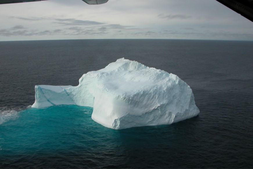
Photo of an iceberg taken from an IIP Ice Reconnaissance Detachment.
Colorful Icebergs
Sometimes icebergs can be quite colorful. It is common to see blue streaks in icebergs and, less frequently, brown stripes. Icebergs that are partly or wholly green have also been seen. Blue stripes are formed when cracks in the ice fill with melt water and the water refreezes. The melt water is nearly bubble free, so it takes on the characteristic blue tint of frozen freshwater. There have been reports of icebergs that were entirely blue such as this description in the 1958 IIP Annual Report:
“An unusual and most interesting iceberg drift occurred during April when, on the 10th, an iceberg was reported south of Heath Point, AnticostiIsland. A Canadian Department of Transport survey flight located this iceberg (or growler) on 14 April and again on 17 April. Capt. Angus Brown, Chief Ice Observer, reported it to be of “hard blue ice” and of glacial origin. This agrees with IIP observations that icebergs with a bluish cast are particularly hard and long lived. This extremely rare iceberg was thought to be a survivor from the many icebergs that were driven through the Strait of Belle Isle during strong NE winds the previous month.”
It is not clear if this blue iceberg is the remnant of a refrozen, melt-water-filled crack, or was the result of some other process.
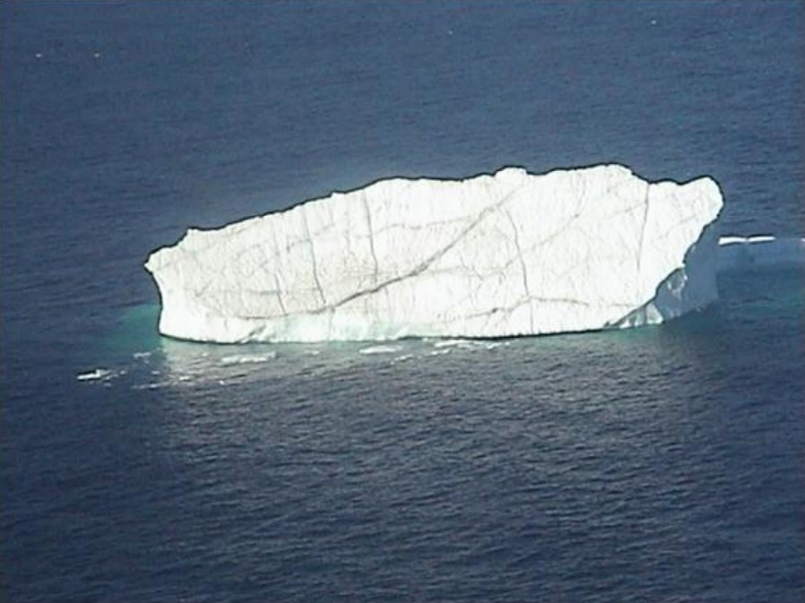
Photo of an iceberg taken from an IIP Ice Reconnaissance Detachment.
Because icebergs originate from land, it is not surprising that dirt and rocks can become embedded within the ice. This can occur in layers creating stripes of varying shades of brown. Much has been written about bottle-green icebergs that are sometimes seen in the Antarctic. Several mechanisms have been proposed, but the most likely explanation for the green color is the freezing of organic-rich seawater to the underwater part of the ice shelf from which the iceberg calved. The green ice is exposed after an iceberg breaks free of the shelf and rolls over.
ICEBERG LOCATIONS
Numerous and massive icebergs from Antarctic ice shelves populate the Southern Ocean, which surrounds the Antarctic continent. Sometimes these icebergs drift into the South Pacific Ocean near New Zealand and into the South Atlantic near the coast of South America.
The Arctic Ocean has several iceberg sources, including the ice shelves of the Canadian Arctic, the Norwegian Svalbard archipelago, and numerous locations in the Russian Arctic. Finally, there are several glaciers, such as the Columbia Glacier in Alaska, that calve icebergs that do not move very far from their source.
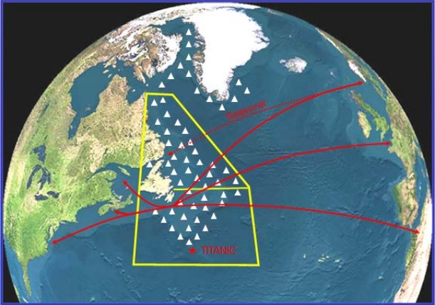
In most years, icebergs enter the North Atlantic shipping lanes (red lines) during the spring and early summer.
Icebergs in Newfoundland
Most of the icebergs that enter the North Atlantic shipping lanes come from the tidewater glaciers of the west coast of Greenland. Once an iceberg is calved from one of these glaciers it completes a 1-3 year journey to arrive in the area that the International Ice Patrol (IIP) monitors.
IIP’s data records, which extend to 1900, show that nearly 500 icebergs enter the shipping lanes in an average year. [The 1900- 2010 average is 479.] However, the year-to-year variation is wide. In 1984, the busiest iceberg year in IIP’s history, 2202 icebergs entered the shipping lanes. On the other hand, during two years (1966 and 2006) no icebergs reached the shipping lanes.
Researchers have struggled for many decades trying to explain the year-to-year variation in the number of icebergs entering the North Atlantic shipping lanes. It is likely that fluctuation in the number of icebergs produced by the Greenland glaciers plays a role in the variability, but it might not be the dominant factor. The oceanographic and meteorological conditions icebergs encounter during their one to three year journey from the glacier’s calving front to the shipping lanes probably play larger roles.
There seems to be a link between IIP’s iceberg counts and the North Atlantic Oscillation (NAO), the dominant pattern of winter atmospheric variability in the North Atlantic. It fluctuates between negative and positive phases. Conditions associated with the negative phase of the NAO are unfavorable to the movement of icebergs toward the shipping lanes. The characteristic features of this phase include persistent onshore winds along the Labrador coast during the winter. This brings relatively warm maritime air to Labrador. The resulting lack of sea ice exposes icebergs to wave-induced deterioration, and the onshore wind moves them toward the shallower waters near the coast, where they can run aground or become trapped in bays. The positive NAO phase, on the other hand, is characterized by strong and persistent northwest winds along the Labrador coast during the winter. These winds bring cold air and extensive sea ice cover, which protects the icebergs during the last part of their journey south, a journey aided by the long-shore wind.
The inter-annual variability in the western North Atlantic iceberg counts remains impressive and difficult to understand and predict. Although the NAO index offers some help, it is clear that there are other mechanisms at work.
SEA ICE
Sea ice is simply frozen sea water. Because sea water contains salt, it freezes at a lower temperature than 0° C, the freezing point of freshwater. The freezing point of sea water varies according to salinity, but generally it freezes at - 1.8° C. There are many different ways to classify sea ice, but there are two major types: first year ice and multi-year ice. As their names imply, first year ice forms and melts in a single year while multi-year ice is ice that has survived at least one melt season.
Sea ice grows and recedes in its extent throughout the year, depending on the season and the temperature of the ocean. In the northern hemisphere, the sea ice extent generally increases from October through March, and decreases from April until September.
For detailed information on the various types of sea ice and its distribution, visit the following web sites:
National Snow and Ice Data Center
CURRENTS
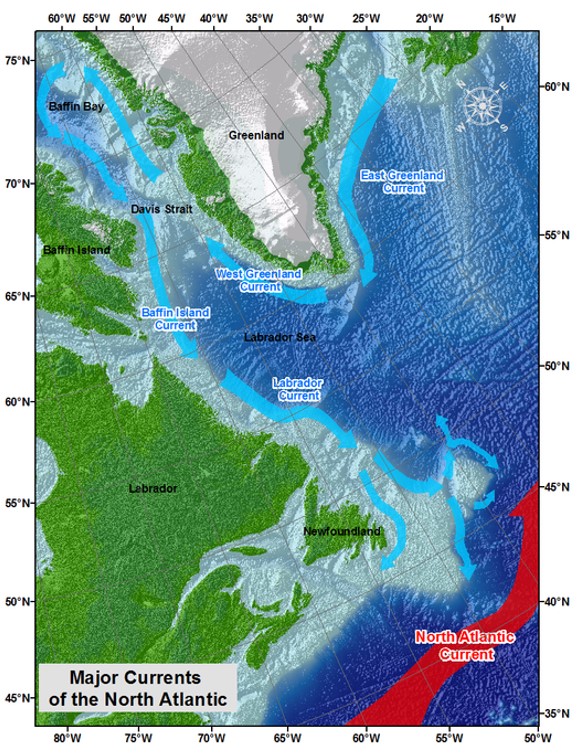
Most of the icebergs originating from the glaciers along the northwest coast of Greenland first move northward and begin a counter-clockwise journey around Baffin Bay (see map below). Eventually, they begin a southward voyage toward the major transatlantic shipping lanes, first in the Baffin Island Current and finally in the Labrador Current (LC). The main branch of the LC, a cold and relatively freshwater current, flows southward along the edge of the continental shelf off the coast of Labrador. It is usually referred to as the Offshore Branch of the Labrador Current. Eventually, it reaches the Grand Banks of Newfoundland where most of it flows southward through the Flemish Pass and along the east side of the Grand Banks. There is a complex and weaker southward flowing current system among the various banks and continental shelf off Labrador. This current, referred to as the Inshore Branch of the LC, eventually flows close to the Newfoundland Coast sometimes bearing icebergs close to shore.
There are two reasons why the offshore branch of the LC is IIP’s primary concern. First, its direction of flow is almost directly southward and can carry icebergs quickly from the north. Second, the LC water is cold, essentially preserving icebergs from rapid warm water deterioration as they move into the shipping lanes. The Offshore Branch of the LC, particularly in the vicinity of the Grand Banks, is sometimes referred to as “Iceberg Alley”.
As the LC reaches the southernmost part of the Grand Banks it begins interacting with the Gulf Stream, which brings warm, and relatively salty, waters northward. The clash between these two diverse currents creates an enormously complicated and dynamic current regime and the persistent foggy conditions for which the Grand Banks are famous.